Investments include water conservation, ecosystem rehabilitation, disaster prevention, and green growth capacity development.
Overview
Tianjin Binhai New Area was established to become a center of finance, business, and industry in the northern PRC to usher further economic development. However, economic boom in the Hai River basin and the Bohai Bay coastal areas since the 1990s already resulted in significant water pollution problems and degradation of natural and environmental resources. How to achieve economic development without aggravating the environment became a critical challenge.
A project funded by ADB demonstrated sound environmental and public safety investments, such as water conservation and ecosystem rehabilitation, disaster prevention and emergency response, and enhanced institutional capacities, to improve environmental and economic conditions at the Harbor Economic Area, a functional area of the new center.
Integrating adequate environmental management practices and risk mitigation measures into development activities, including public infrastructure and industrial investments, is crucial for sustained economic development and green growth.
Project information
43054-013: Hai River Estuary Area Pollution Control and Ecosystem Rehabilitation Project in the PRC
Project snapshot
- Approval date: 13 December 2011
- Closing date: 23 April 2020
- Total project cost: $221 million
- Executing agency: Tianjin Municipal Government through Tianjin Harbor Economic Area Administrative Commission
- Financing: Asian Development Bank, Government of the PRC and Commercial Bank
Context
The Hai River and 15 other rivers flow toward Bohai Bay, which is bounded by the coastlines of Hebei Province, Tianjin municipality, and Shandong Province.
Tianjin has a total area of 11,760 square kilometers (km2) and a population of 11.6 million. It is located at the lowest reach of the Hai River basin.
The Tianjin Binhai New Area was established in 2010 as an economic zone like Shenzhen and the Shanghai Pudong area. The Harbor Economic Area is a land reclamation site in the tidal-flat portion of Bohai Bay, south of the Hai River estuary. The area accommodates large domestic and international companies, including petrochemical industries, shipyards, offshore oil engineering bases, heavy equipment manufacturing, and technological research and development institutes. It also provides residential areas and corresponding public utilities.
Challenges
Rapid economic development in the Hai River basin and the Bohai Bay coastal areas had resulted in the degradation and scarcity of natural and environmental resources. Impacts included polluted waterways, scarcity of water resources in the river basin, and deterioration of the Bohai Sea ecosystems.
The Bohai Bay also suffered from frequent and severe storm surges that had caused severe damage to Tianjin and increased the risks of accidental pollution.
Fast development pace has overshadowed the need to integrate adequate environmental management practices and risk mitigation measures into development activities.
Shifting to sustainable development in the Harbor Economic Area, a new coastal industrial hub, became a challenge for the Tianjin municipal government. Aside from moving to cleaner or nonpolluting industries, the local government needed to improve its capacity for green development and incorporate sustainable features into public infrastructures.
Solutions
In 2011, ADB approved a $100 million loan to demonstrate sound environmental and public safety investments for sustained green growth in the coastal areas of Tianjin. The project built a sewer system and reclaimed water plant for water conservation; eco-efficient wetland for ecosystem rehabilitation; breakwater for storm surge mitigation, taking into accounts climate change impacts; and an environmental monitoring and emergency response center to offer a comprehensive platform for environmental monitoring and emergency management.
The ADB also provided a $1 million technical assistance grant to enhance the capacity of the executing and implementing agencies to pursue green growth. The technical assistance introduced international best practices on harbor and industrial park management, supported the International Organization for Standardization (ISO) certification of the government’s construction and development company, and helped establish the said emergency response center.
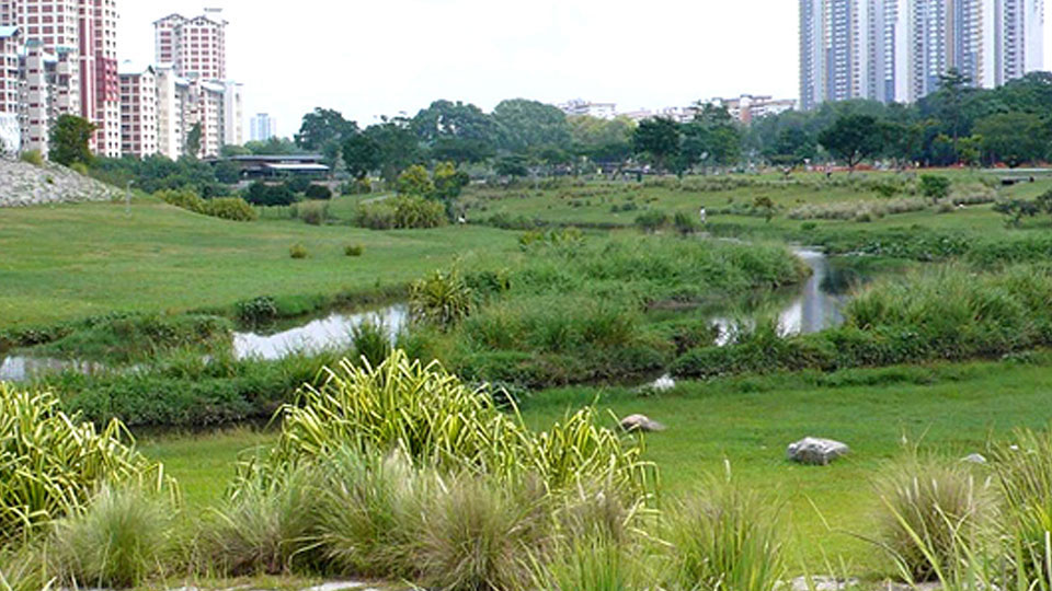
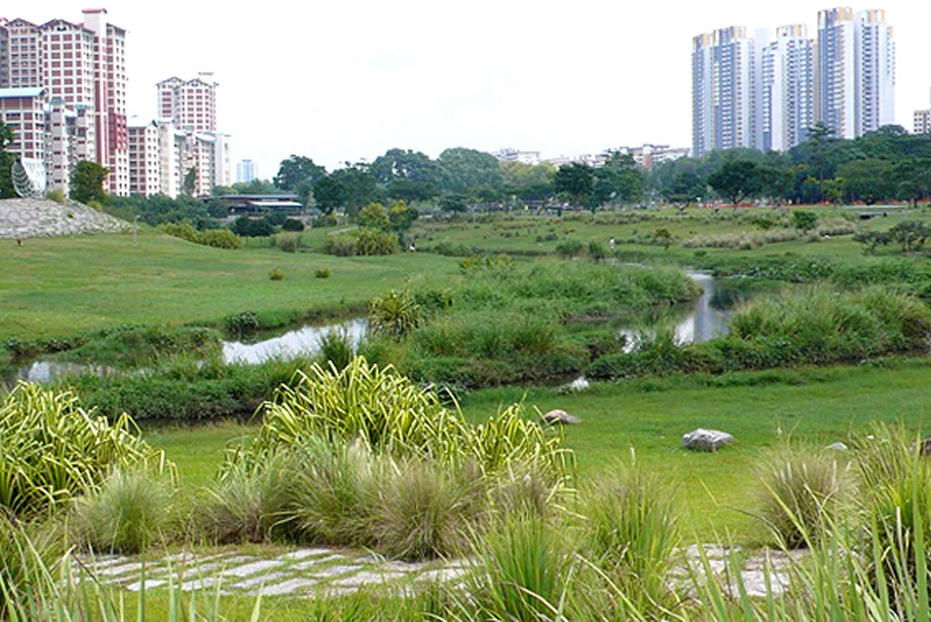
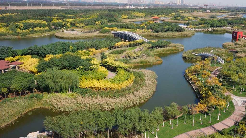
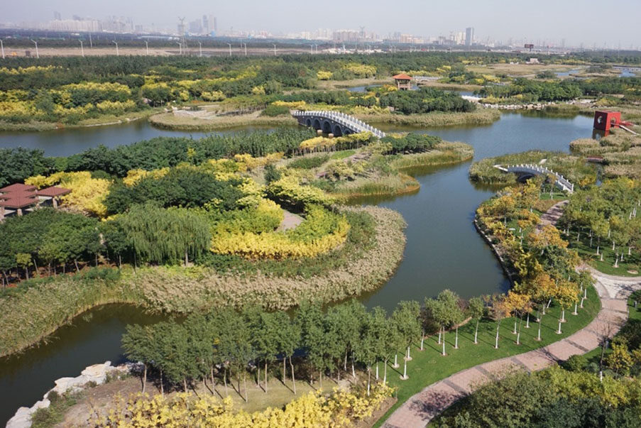
The project constructed a 15,000-cubic meter per day (m3/day) wastewater treatment plant (WWTP), a 10,000 m3/day reverse osmosis reclaimed water plant, 42 kilometers (km) of sewer pipelines, 21 km of stormwater pipes, and 41 km of reclaimed water pipes. A multi-functional wetland park was designed for advanced sewage treatment, water regulating, biodiversity conservation, and culture services for surrounding areas. The 63-hectare (ha) wetland with treatment capacity from Class 1B to Class 1A was constructed with low impact development feature. The effluent from wastewater treatment plants is purified by the wetland and used as landscape and greening water.
The project constructed a prevention wall (breakwater) to minimize risks and damage caused by storm surges and to ensure safe and efficient working conditions in the Harbor Economic Area. The prevention wall is about 3 km long with a once-in-50-year design standard, taking into consideration climate change impacts. An environmental monitoring and emergency response center was established to deal with pollutants and emergencies arising in the coastal industrial hub. The center holds the first comprehensive environmental monitoring and emergency management platform in Tianjin that integrates information collection and analysis, monitoring and early warning, decision support, dispatching and command, and accident handling and evaluation.
The project consultants provided advisory services and training for implementing institutions in design review, construction and procurement management, quality management, information management, and project monitoring and reporting. Manuals on low-pressure sewer system and low-impact development approaches were produced for application in the Harbor Economic Area.
The technical assistance helped the Harbor Industrial Park Construction and Development Company (HIPCDC) obtain ISO certifications on quality management and environmental management system; trained government officials on best practices in managing industrial parks and harbors; organized quantitative risk assessment and emergency response management workshops, reviewed emergency response plans of chemical and petrochemical plants, and conducted drills; and assisted in the concept design of the environmental monitoring and emergency response center.
Results
The improved wastewater treatment facilities reduced pollutant emissions. Around 59% of the treated wastewater from the treatment plants in the Harbor Economic Area is recycled for reuse; and about 37% of water supply in the Tianjin Binhai New Area come from nontraditional sources, such as reclaimed water and desalinated water, to overcome water scarcity.
The wetland park serves as a habitat for coastal species and a leisure site for citizens. Wild birds increased from 29 species in 2015 to 113 species in 2017. The wetland park also received more than 100,000 visitors as a relaxation place and an environmental education base for residents in the neighboring areas. The water quality is improved after flowing through the wetland.
The breakwater lowered the risk of storm surge losses, increased the capacity and efficiency of cargo berth, improved the safety of shipping and dock loading, and minimized maintenance dredging at docks through reduced back silting.
The environmental monitoring and emergency response center enhanced the government’s ability to respond promptly to various production and environmental pollution accidents and regulate the production and discharge behavior of enterprises in the Harbor Economic Area. The integrated analysis, proactive traffic management of hazardous vehicles, monitoring and risk detection, and emergency response plans effectively reduced the risk of accidents. Overall disaster prevention and response plans mitigate risks of the Harbor Economic Area from economic losses, injury, and environmental pollution.
HIPCDC, the government’s construction and development company, obtained ISO certifications for quality management system and environmental management system. Since 2014, the ISO-certified systems were applied to the company’s core business, including land development, municipal infrastructure development, and leasing services for the houses and public facilities in the industrial hub.
Good environmental management practices and risk mitigation measures are also integrated into non-project development activities in the area. Green growth in the Bohai Bay coastal areas of the Tianjin municipality has been gradually sustained. Eco-efficiency and recycling activities, such as the constructed wetland and reclaimed water plant, have been replicated in other coastal areas of Tianjin municipality. In 2019, the Lingang Area (the new name of the Harbor Economic Area after merging with the Tianjin Port Free Trade Zone in December 2017) was recognized as a municipality-level demonstration zone of a recycling economy. In 2020, the Tianjin Port Free Trade Zone, including Lingang Area, was identified as a state-level Green Industrial Park for green and sustainable development.
Lessons
Reclaiming treated wastewater for reuse can help overcome water scarcity. Constructed wetland can be designed to provide multiple ecological functions beyond wastewater treatment.
A comprehensive environmental monitoring and emergency management mechanism is important for pollution and disaster management of an industrial area with high environmental risks.
Holistic planning, precise design, and accurate implementation are keys for success in eco-efficient and recycling activities. The construction of the wastewater treatment plant and reclaimed water plant should be synchronized with the pace of overall industry and infrastructure development. Although it was planned so, the actual construction of the plants was delayed because of external factors. Otherwise, the financial viability of this project component would be better.
Getting government’s construction and development companies with ISO environmental management certification is also a way to quality and responsible development as this kind of certification institutionalize environmental management capacity through a systematic approach that generates wide impact. These companies are often commissioned by the government for land development and infrastructure construction in the PRC.
Enhanced capacities of institutions and staff are vital for sustaining green growth beyond the project. Knowledge and understanding of best practices widen their vision for green development, ecological and environmental protection, emergency response, and industrial park and port management. New skills and a change in mindset benefit work beyond the project and are considered as an asset to organizations.
References
Asian Development Bank (ADB). 2011. Report and Recommendation of the President to the Board of Directors on a Proposed Loan and Technical Assistance Grant to the People’s Republic of China for the Hai River Estuary Area Pollution Control and Ecosystem Rehabilitation Project. Manila.
ADB. 2021. Completion Report: Hai River Estuary Area Pollution Control and Ecosystem Rehabilitation Project in the People’s Republic of China. Manila.
Author

Xin Shen
Senior Project Officer (Natural Resources and Agriculture), East Asia Department, ADB
This blog is reproduced from Development Asia.