A data-driven “smart” system can help water utilities to reduce losses from unaccounted-for-water more efficiently and improve service delivery.
Introduction
Artificial intelligence (AI) offers water utilities the potential to enhance service delivery, optimize investments, and reduce costs. It can improve the efficiency of water supply systems by maximizing information and data available to make better operational and planning decisions. For example, AI tools may be used to inform efforts to reduce losses from nonrevenue and unaccounted for water, such as from leaking pipes and inaccurate meter readings.
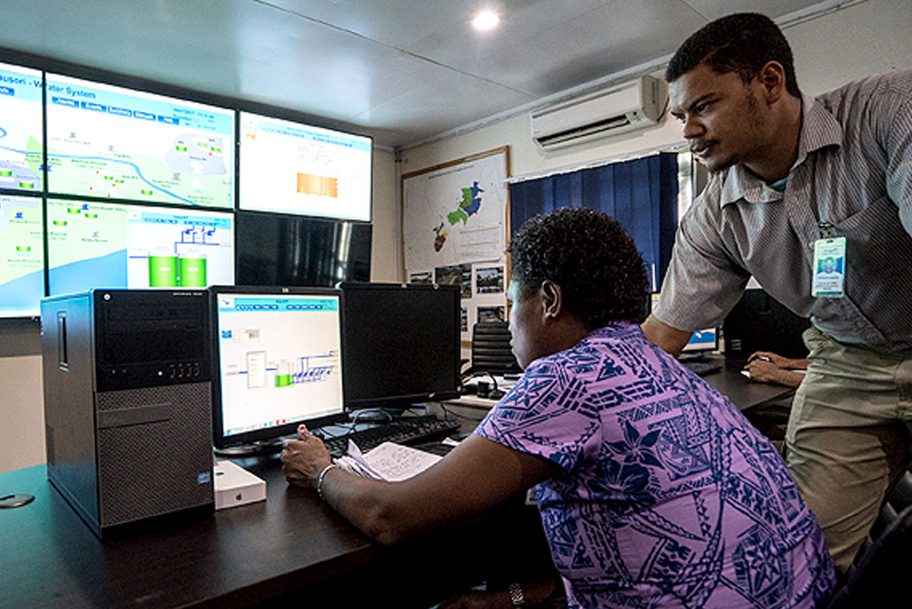
The availability of affordable big data from sensors, customers, and staff builds the case for the digital transformation of the water sector. However, many water utilities, particularly in developing countries, lack the capacity to use big data for day-to-day operations. Most of them start their digital transition with a supervisory control and data acquisition (SCADA) system linked to a network control center; then figure out how to turn these technology investments into real benefits to customers.
The digital transition of water utilities should be progressive, pragmatic, and target-oriented. From an “old school” operation or Hydraulic Modeling 1.0, water utilities need to shift to a new era of efficiency and accountability, or Hydraulic Modeling 2.0, supported by AI tools and big data analytics.
This explainer is adapted from an Asian Development Bank publication(link is external) that discusses the principles and applications of AI for water utilities to improve water distribution operation, how to pilot AI to address unaccounted-for-water problems, and policies to support digital adoption.
What is Hydraulic Modeling 2.0?
It is a new network analysis approach that encompasses the joint application of several methods to provide a dynamic, probabilistic representation of water distribution networks. It allows the numerical detection of unaccounted-for-water.
Hydraulic Modeling 2.0 is the way forward for water utilities to embrace AI or machine learning at the core of their planning and operations. It represents a qualitative step forward compared to the conventional Hydraulic Modeling 1.0 currently used. The key differences are summarized in the table below.
Hydraulic Modeling 2.0 combines physically based and data-driven methods for water distribution network analysis. Physically based methods draw on the combination of statistical tools, such as state estimation techniques and pressure sensitivity analysis, with hydraulic modeling.[1] Data-driven methods are based on the application of AI or machine learning algorithms as artificial neural networks (with their many variations generally known as deep learning methods), as well as support vector machines, classification trees, adaptive neuro-fuzzy inference systems, etc.
Table 1: A Comparison of Hydraulic Modeling 1.0 and 2.0
| Hydraulic Modeling 1.0 (Conventional) | Hydraulic Modeling 2.0 |
|---|---|
| Deterministic System represented by average values of the state variables (flows and p | Probabilistic All variables treated as probabilistic with their density functions and cross-correlations. |
| One-off calibration Hydraulic model calibrated once a year (at best) based on aggregate error functions. Model parameters are usually fixed. | Continuous learning Hydraulic model real-time learning with new data generated: calibration constantly updated with past and current data. |
| Limited data Hydraulic model set up with limited data without the need for real-time data, except to update water consumption. More data does not imply better model. | Big data Hydraulic model maximizes all data available (the more data, the better): well suited to a data-rich and real-time environment. |
| Simplification Uncertainty in water demand at the nodes not quantified and not considered | Uncertainties Water demand reflects the uncertainty from the meters’ errors and the aggregation of nodes when no meter is available. |
| Shortcut Measurements’ errors for flows and pressures not considered. | Holistic Measurement errors from sensors introduced into the model with a non-negligible impact on the results. |
| Anomalies Anomalies mostly not detected or if so, not characterized, nor classified. | Classification and sorting The algorithm analyzes the residuals values (differences between field data and model results) and classifies them into categories: illegal connections, water leaks, pipe bursts, malfunctioning sensors, abnormal water consumption patterns, etc. |
Source: Asian Development Bank.
What are the first steps toward a smart water system?
From the point of view of operations, physically based methods are the starting point for water utilities into their digital transformation. The next step is to integrate data from SCADA with advanced hydraulic modeling tools—comprising AI in water supply—through data-driven approaches. This supplements the physically based methods with powerful optimization and decision support tools, business intelligence, and knowledge management.
For a medium-size water utility (less than 100,000 connections) with little experience in smart water, the initial operational assessment would identify where digital transformation brings the largest benefits (“low-hanging fruits”), and then a smart water road map should be drafted. A typical starter digital transformation package would look into
- defining operational targets and key performance indicators (KPIs);
- integrating network analysis tools that provide the diagnosis and the decision support to achieve the KPIs;
- developing an optimal monitoring network to obtain the maximum amount of information based on a minimum number of strategically placed sensors with the lowest ratio of flowmeters versus pressure gauges to minimize costs; and
- implementing a SCADA basic solution for the distribution network.
How can AI improve unaccounted-for-water reduction?
Unaccounted-for-water is a key indicator of the operational and financial performance of a water utility. It is a benchmark of a water utility’s efficiency in reducing both physical losses (e.g., water leaks and pipe bursts) and commercial losses (such as illegal connection and metering errors).
Techniques to physically detect water leaks combine special equipment (acoustic sensors, gas tracers, etc.) with human skills. A current trend is to incorporate AI in some of the hardware (for instance, acoustic correlators) to replace humans in interpreting the data (water leak noises). Advances in numerical modeling of the hydraulics of water distribution networks also now make it possible to detect potential leaking pipe sectors through numerical methods, as long as the hydraulic models are fed with a sufficient amount of calibrated field data such as pressure, flow, and node consumptions.
A 2019 white paper shows that smart water technologies could reduce a water utility’s total cost by 7.4% (baseline costs), with most of the savings coming from efficient utilization of capital expenditures and improved unaccounted-for-water reduction. Although the AI algorithms’ contribution is not broken down, most of the gains are assumed to come from data processing and analysis, since sensors and data on their own provide little direct benefit.
How to pilot test AI for unaccounted-for-water
Water utilities can test the potential benefits of AI techniques by embarking on low-risk, low-scale pilot projects that can also be used to assess their technological capacities and define a realistic smart water road map.
Piloting the concept of AI and Hydraulic Modeling 2.0 for unaccounted-for-water would demonstrate how advanced network analysis algorithms improve operational efficiency and service delivery. This involves harnessing the power of AI combined with big data sourced from the SCADA system, as fed from the various sensors on the water distribution network.
An AI pilot analyzes numerical unaccounted-for-water and pipe burst detection as well as sensor failure routines on the primary water distribution network (pipe diameter of over 200 millimeters). The AI algorithms are tested on one water distribution network sector or a small water distribution system.
The AI pilot starts with an off-line demonstration making a hindcast based on historical records collected by the water utility on the selected portion of the water distribution system. A hindcast (also known as back-testing) involves testing using a mathematical model. Known or closely estimated inputs for past events are entered into the model and compared with output against known results.
A typical pilot project (phase 1) would consist of several sequential tasks over 9–12 months:
- Task 1: selection and validation of the pilot site in agreement with the water utility’s representatives (1 month);
- Task 2: initial analysis of the pilot site and data provided by the water utility to check for inconsistencies, data gaps, and other issues (1–2 months);
- Task 3: setting up and localization of the AI algorithms (3–4 months); and
- Task 4: exploitation of AI algorithms using historical data in a hindcast mode (4–6 months).
After completing the off-line testing of the AI algorithms, phase 2 can start using the AI algorithms in real-time operation, including for the prognosis of unaccounted-for-water. The need to integrate the numerical results with the current operation and the development of complementary algorithms suggests another 18 months to implementation for phase 2. Based on the real-time results and experience, the AI pilot can be upscaled to the entire water distribution system.
For a water utility with less than 25,000 connections, corresponding to a city of 100,000 inhabitants, the cost of implementing a smart water project with an AI pilot would be around $2 million ($10 to $20 per person, or around $0.5 to $1 per month and service connection, in variable terms).
What are the key areas for policy action to support digital transformation?
The use of AI has several policy implications to improve the performance of water utilities and the quality of the service delivery.
- Ethics and governance deal with the protection of personal and financial data from consumers, and technical and financial data from water utilities.
- Regulation deals with benchmarking, since unaccounted-for-water is one of the key operational parameters to determine the efficiency of a water utility.[2]
- Technical policies deal with line ministries and water associations to update the national and water “Code of Practice,” and to guide water utilities in their digital transformation.
- Financial policies address short-term capital expenditure requirements to finance smart water utilities with new financing instruments.
Development partners can support line ministries and water associations in developing technical guidelines and strengthening regulations, governance, and ethics resulting from the introduction of powerful AI numerical tools.
The financing requirements of smart water utilities can be supported by customizing the energy savings business model (with energy savings companies) through funding based on a digital and smart water road map and payback, and secured through operational improvements guaranteed by water tariff increases resulting from the enhanced service delivery to customers.
[1] D. Jung and J. H. Kim. 2018. State Estimation Network Design for Water Distribution Systems. Journal of Water Resources Planning and Management. 144 (1); S. G. Vrachimis, D. G. Eliades, and M. M. Polycarpou. 2018. Real-time Hydraulic Interval State Estimation for Water Transport Networks: A Case Study. Drinking Water Engineering and Science. 11 (1). pp. 19–24; S. Díaz, J. González, and R. Mínguez. 2016. Uncertainty Evaluation for Constrained State Estimation in Water Distribution Systems. Journal of Water Resources Planning and Management. 142 (12); H. R. Asgari and M. F. Maghrebi. 2016. Application of Nodal Pressure Measurements in Leak Detection. Flow Measurement and Instrumentation. 50. pp. 128–134; and R. Pérez et al. 2011. Methodology for Leakage Isolation Using Pressure Sensitivity Analysis in Water Distribution Networks. Control Engineering Practice. 19 (10).
[2] The International Benchmarking Network for Water and Sanitation Utilities (funded by the World Bank Group and the International Water Association with the support of other development partners and stakeholders) promotes good benchmarking practices among water and sanitation services. See International Benchmarking Network. https://www.ib-net.org/.
Resources
D. Jung and J. H. Kim. 2018. State Estimation Network Design for Water Distribution Systems. Journal of Water Resources Planning and Management. 144 (1).
H. Jenny et al. 2020. Using Artificial Intelligence for Smart Water Management Systems. ADB Briefs. 143. June. Manila: Asian Development Bank.
H. R. Asgari and M. F. Maghrebi. 2016. Application of Nodal Pressure Measurements in Leak Detection. Flow Measurement and Instrumentation. 50. pp. 128–134.
International Benchmarking Network.
R. Pérez et al. 2011. Methodology for Leakage Isolation Using Pressure Sensitivity Analysis in Water Distribution Networks. Control Engineering Practice. 19 (10).
S. Díaz, J. González, and R. Mínguez. 2016. Uncertainty Evaluation for Constrained State Estimation in Water Distribution Systems. Journal of Water Resources Planning and Management. 142 (12).
Sensus. 2020. Improving Utility Performance Through Analytics: Market Research Report. White Paper.
S. G. Vrachimis, D. G. Eliades, and M. M. Polycarpou. 2018. Real-time Hydraulic Interval State Estimation for Water Transport Networks: A Case Study. Drinking Water Engineering and Science. 11 (1). pp. 19–24.
Author

Wang Yihong
Senior Investment Officer, East Asia Department, Asian Development Bank

Eduardo Garcia Alonso
Consultant, Asian Development Bank

Roberto Mínguez Solana
Consultant, Asian Development Bank
Disclaimer: The views expressed in this blog are those of the authors and do not necessarily reflect the views of ADB, its management, Board of Directors or members.